
Manchester Neighbors: Records at a Glance
In Hartford County, a block lookup combines map, parcel, title, civic, and historical sources. Each one shows a different layer around the target address. The table keeps a neighbor search from confusing a parcel owner with every person who lives nearby.
| Source | What it shows about a block | Access and caution |
|---|---|---|
| GIS parcel viewer | Adjacent parcel shapes, addresses/RPKEYs, buildings, roads, and layers | Free map; click parcels; not a survey |
| Vision Street Listing | Assessment entries, owner fields, mailing and situs context | Free; owner is not occupancy proof |
| RecordHUB | Historical title parties across nearby parcels | 1823-current description; portal and copy terms apply |
| Voter status | One exact name and date-of-birth registration check | Not an address browse; full file restricted |
| Neighborhood and civic sources | Named areas, public groups, boards, duties, and contacts | No consolidated private member roster located |
| Library and History Center | Historical nearby households through directories, newspapers, yearbooks, and maps | Reference access; not a current complete list |
Owners can be absent from a property because a trust, corporation, bank, attorney, or out-of-town mailing address is involved. Occupants can be absent because property records do not list every household member. That difference is the first privacy boundary in a Manchester neighbors lookup.
Map the Manchester Neighbors Around One Address
The documented GIS method is visual adjacent-parcel browsing. Search the target address, RPKEY, or street name in the Town viewer. Keep the map at a scale that shows the neighboring boundaries, then click each parcel. Turn on parcels, address points and ranges, buildings, roads, lot dimensions, zoning, flood and wetlands, easements, historic layers, utilities, and street names only as needed.
- Start with the target address and save its Vision PID or MBLU, situs, mailing address, and legal-description clue.
- Open the GIS viewer and click the target parcel. Add adjacent parcels one at a time instead of treating a broad map as a complete block list.
- Run each adjacent PID or address through Vision and record the owner and mailing context separately.
- Use RecordHUB when title history or a filed map matters. Compare legal descriptions because a street number can cover more than one lot or unit.
- For a whole named street, switch to the Manchester by-street walkthrough; for the immediate block, keep the parcel set small and dated.
The viewer supports property reports and map downloads after a parcel is selected. It does not expose an official automated “nearby parcels within a set distance” result in the inspected controls. The service also has query limits for some layers, so a broad extent may not show every feature.
Manchester Neighbors: Maps Are Not Surveys
Manchester GIS documentation says the public layers are compiled from deeds, filed plots, subdivision plans, and other public records, updated as needed, provided without warranty, and not intended for assessment, legal survey, or boundary determination. The map is excellent for finding a nearby parcel, road, easement, building, or address range. It is not the final word on a line between properties.
Use a recorded deed, filed map, or qualified surveyor when a boundary or title question has legal consequences. Do not infer a household from a building footprint, utility line, flood layer, or mailing address. These are physical or administrative layers, not people layers.
Compare Manchester Neighbor Owners in Vision
Vision's Address, Owner, Acct#, PID, and MBLU modes help compare adjacent parcels. A Street Listing control can browse a named street, while the sales search adds a date range, sale price, land size, building area, model, neighborhood, and style filters. Preserve the parcel ID for each nearby record because corner parcels, condominium units, and several buildings can produce multiple entries.
| Situs | Physical parcel location; use it to align the map and assessment result. |
|---|---|
| Mailing | Destination for the owner or tax bill; it may be outside Manchester. |
| PID or MBLU | Stable assessment locator for comparing adjacent records. |
| Assessment traits | Land, building, extra features, outbuildings, valuation history, and neighborhood context. |
A Vision result is a property record. It can support a parcel comparison, but it cannot confirm every person who lives at the address or every neighbor who visits the block.
Follow Title Across Manchester Blocks
RecordHUB connects a nearby parcel to the filed title history. Search a current owner as grantee, open the deed or map, record the grantor and legal description, and then search the grantor as an earlier grantee. Related mortgages, releases, liens, foreclosure registrations, maps, and trade names can explain a parcel's history without proving that a party occupied it.
Manchester's local land-record span is 1823-current. The portal can lag a few days, older paper images can be difficult to read, and exact live search fields were not exposed without an account. Use original books or a Town Clerk rescan route when a result matters. A title trail across nearby parcels is a research chain, not a present-day list of nearby people.
Manchester Neighbors and Voter Visibility on a Block
Connecticut's public voter lookup can confirm a narrow registration status with a full first name, last name, and date of birth. It may return party, polling place, and absentee status. The Manchester Registrar of Voters maintains the local file at 479 Main Street and can help with a precise status question. The lookup does not offer an open address browse for every neighbor on a block.
The full CVRS file is a $300 CSV request with a use certification for election-related, scholarly, journalistic, political, or governmental work. Personal or private copying, marketing, sale, reproduction, and harassment are restricted. Safe at Home participants and protected voters may use substitute addresses or be absent from ordinary output. A neighbor lookup should state that limit instead of offering an informal voter roster.
Thirteen Manchester Neighborhood Labels
The official 2017 Manchester neighborhood map names Keeney, Martin, Buckley, Robertson, Highland Park, Buckland, Center, Waddell, Bowers, Spencer, West Side, East Side, and Verplanck. Historical material also uses Parker, Hilliardville, Meekville, and Taylorville. Main Street and Center Street organize the Community Youth, Family and Neighborhood Plan's four-quadrant framework. These names are useful search terms, not membership lists.
Use a neighborhood name to locate a map, directory, newspaper story, yearbook, church or civic reference. Then connect the historical clue back to a current parcel, street, or public office. A named area can explain why two sources describe the same Manchester block differently.
Manchester Neighbors: Civic Contacts, Not Private Rosters
Manchester's Neighborhoods and Families Division works from 153 Spruce Street and can be reached at 860-647-3089. The Community Youth, Family and Neighborhood Plan describes resident, service, organization, youth, and elder participation, but it does not publish a private member directory. The town's BoardTracker supplies a separate civic-contact layer for appointed groups, duties, terms, and public member or contact fields.
| Public route | What it can provide | What it does not promise |
|---|---|---|
| Neighborhoods and Families | Umbrella community-partnership route and public contact | A private association membership list |
| BoardTracker | Appointed groups, duties, terms, and public contact fields | Every neighborhood resident or private member |
| Official neighborhood map | Thirteen named area labels and street geography | A roster or current block boundary for every purpose |
| Library and History Center | Historical directories, maps, newspapers, yearbooks, and civic context | A current neighborhood directory |
The sources reviewed did not locate a consolidated Manchester HOA, block-watch, congregation, or association membership directory. Ask a group for public meeting or contact information, not private member data.
The Manchester BoardTracker listing is the available civic-directory example.
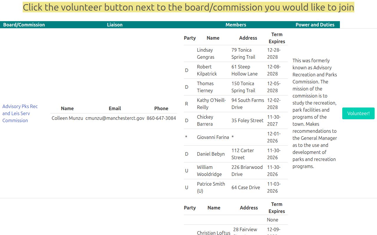
The captured listing shows public appointed-group information. It should orient a civic search, not be copied into a private neighbor roster.
Manchester Neighbors in Local Collections
The library's directory shelf begins in 1891, and the Historical Society has named runs from 1917, 1922, 1927, 1934, and 1946. The Manchester Newspaper Database, History Center yearbooks, Cheney oral histories, census schedules through 1950, cemetery books, and maps can show who was connected to a block in an earlier period. A reverse or criss-cross directory is not verified as a complete local series, so ask staff which volume is address ordered.
Historical neighbors are best used for family history, house history, former classmates, civic research, and reconnecting. Compare a printed entry with a deed, census, obituary, or cemetery record. Do not treat a decades-old address as a current location.
Manchester Neighbor Tools and Official Rolls
Official sources begin with a custodian, record type, date, and stated access rule. Commercial neighbor tools are compiled datasets assembled from filings, address histories, and matching algorithms. They may merge same-name people, retain stale information, omit protected participants, or present an inference as a fact. The original Manchester or Connecticut office remains the place to correct or certify a record.
| Source type | Strength | Weakness to document |
|---|---|---|
| GIS and Vision | Parcel location and assessment context | Owner is not every occupant; GIS is not a survey |
| RecordHUB | Filed title parties and legal descriptions | Title is not proof of presence |
| Library collections | Dated historical names and addresses | Not current or complete |
| Commercial compilation | May surface a lead | Freshness, matching, cost, and lawful-use limits vary |
Privacy Limits on Manchester Neighbors
Property and map records do not normally show household members, utility customers, delivery records, or a complete list of people present. Connecticut's Address Confidentiality Program gives qualifying participants a substitute mailing address, and DMV personal information is protected under federal and state law. Court, voter, vital, adoption, juvenile, and sealed records have separate boundaries.
Lawful use. A Manchester neighbors lookup is for getting to know a block, reconnecting, family history, civic work, and personal safety awareness. Never use it to watch, harass, intimidate, or harm another person.
If a map, owner field, or civic listing appears wrong, contact the originating custodian. Do not defeat a substitute address, publish a protected location, or turn a public parcel record into a private household profile.